Il Forte Puin, situato sul crinale tra la Val Polcevera e la Val Bisagno, è una delle fortificazioni ottocentesche che compongono il famoso sistema difensivo dei Forti di Genova. Costruito tra il 1815 e il 1830 dal Regno di Sardegna, il forte aveva una funzione strategica: sorvegliare i collegamenti tra le due vallate e rafforzare la difesa settentrionale della città.
Caratteristiche architettoniche
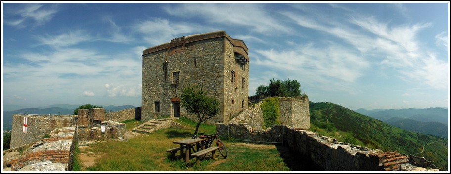
Forte Puin si distingue per la sua pianta compatta, composta da un corpo centrale a due livelli con cortile interno e camminamenti protetti. Era progettato per ospitare una guarnigione ridotta e disponeva di postazioni per l’artiglieria leggera, ideali per il controllo visivo e militare del territorio circostante.
Il forte è stato attivo fino alla fine del XIX secolo, dopodiché ha perso la sua funzione militare.
Un luogo da scoprire, tra storia e natura
Oggi Forte Puin è meta apprezzata da escursionisti, amanti della natura e appassionati di storia militare. Inserito nel Parco delle Mura di Genova, è raggiungibile tramite piacevoli sentieri panoramici che partono da Righi, facilmente accessibile con la funicolare.
Dalla terrazza del forte si gode una vista spettacolare su Genova, sul mar Ligure e sulle valli interne, rendendo questo luogo ideale per escursioni, fotografia naturalistica e visite guidate.
Perché visitare Forte Puin
Il forte è visitabile esternamente tutto l’anno. In alcune occasioni viene aperto anche all’interno per eventi, visite culturali o attività educative organizzate dal Comune di Genova o da associazioni locali.
Panorama mozzafiato sulla città e sul mare
Immerso nella natura del Parco delle Mura
Raggiungibile con una facile escursione da Genova
Perfetto per una gita fuori porta culturale


(Tratto da “I forti di Genova” Sagep Editice)