
Il Forte della Crocetta si trova a 160 metri d’altitudine, sopra la valle Polcevera, nel cuore delle alture genovesi.
Come arrivare
Percorso diretto:Si raggiunge percorrendo corso Martinetti e corso Belvedere, da cui si prosegue a piedi verso il forte, visibile in meno di 5 minuti di cammino.
Percorso alternativo: Più suggestivo e meno conosciuto, parte dalla Tenaglia, lungo una linea trincerata costruita nel 1826. Lungo il tragitto si trova la torre Granara, rimasta incompleta e trasformata in postazione scoperta.
Da lì, la barriera termina con una porta che immette in “Salita al Forte Crocetta”, divenendo una strada campestre per Begato.
Altro accesso possibile è da salita V. Bersezio, sempre da Begato.
Il nome “Crocetta” proviene da un convento degli Agostiniani terminato nel 1609, con annessa una chiesetta intitolata al SS. Crocifisso. Nel 1771 ospitava 17 religiosi. Il convento fu soppresso nel 1798 e demolito nel 1815
Evoluzione militare
Già nel 1747 la zona era strategicamente fortificata con trincee e batterie che comunicavano con il Belvedere e Sampierdarena.
Durante il periodo napoleonico, il terreno venne sistemato in forma poligonale e vennero riutilizzate alcune strutture conventuali.
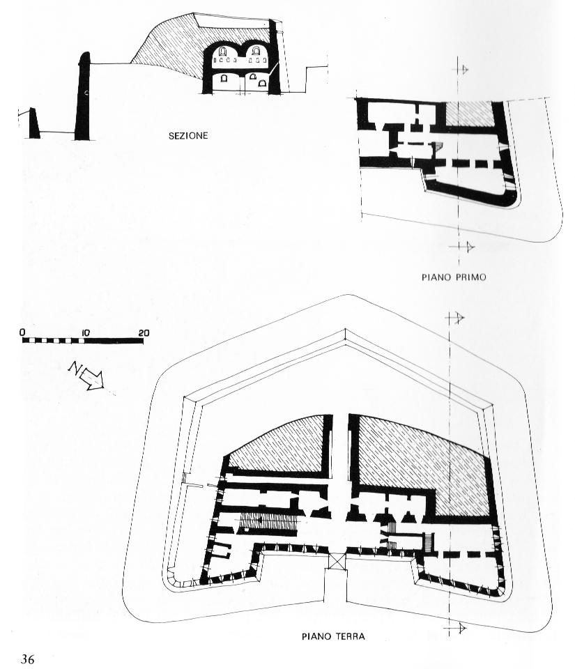
Costruzione del forte
Dopo l’annessione al Regno Sardo (1815), si iniziò la costruzione vera e propria del forte, completata in due fasi:
Prima fase (1819-1823): struttura trapezoidale con semibaluardi e terrapieno basso.
Seconda fase (1827): rialzato di un piano, aggiunto un fossato largo 7 metri e un ponte levatoio. La porta fu spostata al primo piano.
All’interno troviamo:
– Cortile d’ingresso, corpo di guardia e alloggio del comandante.
– Corridoio centrale verso il terrapieno, magazzini d’artiglieria e polveri.
– Piattaforma superiore per fucileria e piccoli calibri.
Il forte presenta un manto di terra protettivo (10 metri verso valle) per assorbire i colpi nemici.
Eventi storici
Nel 1849, dopo la resa genovese ai Piemontesi di La Marmora, fu usato come prigione per i ribelli di Tenaglia, Crocetta e Belvedere.
Caratteristiche architettoniche
Il forte si distingue per elementi innovativi:
– Terrapieno mimetico visibile da valle.
– Facciata con portale ad arco, paraste in mattoni e feritoie.
– Cordolo in laterizio lungo i parapetti.
Sulla salita era presente anche l’ufficio del dazio di Sampierdarena.
Il Forte è chiuso al pubblico, ma ben conservato e di grande interesse storico.


(Tratto da “Fortificazioni campali e permanenti di Genova” di R. Finocchio, Valentini Editore)

(Piantina tratta da “I forti di Genova” Sagep Editice)