Nel 1747, l’area che oggi ospita il Forte Belvedere era priva di vere strutture militari. Tuttavia, il Maresciallo Sicre e l’Ingegnere De Cotte progettarono un vasto sistema difensivo che si estendeva dalla chiesa di Nostra Signora del Belvedere fino alla foce del torrente Polcevera, includendo trincee, muretti, crôse, orti con parapetti e rudimentali bastioni. Un assetto semplice ma strategico, che sfruttava ogni elemento naturale per offrire protezione flessibile contro l’artiglieria nemica.
Nel maggio 1748, la Giunta delle Fortificazioni definì il numero di cannoni da posizionare alle trincee del Belvedere e della Crocetta.
Tra guerra e abbandono (1795–1800)
Terminata la Guerra di Successione, le difese occidentali vennero progressivamente abbandonate in favore di postazioni più arretrate come San Benigno, la Tenaglia e le Mura degli Angeli. Una relazione del 1795 evidenziava l’assenza di artiglieria nei vecchi trinceramenti, giudicati non più necessari. Durante l’assedio del 1800, il crinale del Belvedere, seppur esposto, non fu impiegato attivamente grazie alla sorveglianza del Bastione della Concezione e della struttura “a corno” della Tenaglia.
La rinascita sotto il Regno Sardo (1815–1827)
Nel 1815, il Genio Militare Piemontese avviò la costruzione del Forte Belvedere, completandolo nel 1827. I primi progetti si basavano su mappe dettagliate e schizzi a matita, tra cui la Tavola E 322, che mostra l’antico monastero e una strada corrispondente all’attuale Salita Millelire.
Il Forte nacque attorno a una casa-forte napoleonica simile alle ridotte dei Due Fratelli. A nord e ovest erano visibili resti dei trinceramenti settecenteschi. Un segmento di muratura, oggi corrispondente alla crôsa che conduce a valle, fungeva da strada coperta verso Sampierdarena.
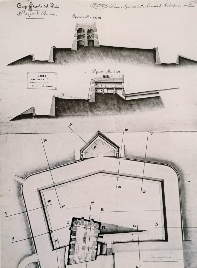
Struttura e architettura del Forte
Poiché il terreno risultava troppo uniforme per una costruzione compatta come il Forte Crocetta, venne esclusa l’idea di abbattere il convento per realizzare un fortino trilobato. Si optò invece per posizionare una batteria davanti al convento, come testimoniato da una lapide interna.
Corpo del Genio Sardo progettò una struttura “a lunetta” pentagonale, protetta da fossato e alto muro di controscarpa. Il disegno esterno richiama quello del Forte Crocetta, ma si distingue per un bastione sporgente rivolto verso la Val Polcevera.
Dettagli architettonici unici
Collegamento con l’esterno tramite una galleria sotterranea illuminata da aperture rotonde in pietra ancora visibili.
Presenza di una lunetta triangolare su un dosso, collegata da un corridoio con feritoie.
Murature perimetrali rastremate su tre livelli, con terrazza a prova di bomba.
Sequenze di cannoniere e contrafforti semicircolari che conferiscono slancio alla casa-forte.
Smussature angolari e accessi ridisegnati per resistere meglio al fuoco nemico.

Da “Fortificazioni di Genova” di L.C. Forti